Топик «Географическое положение Великобритании» (Geographical position of Great Britain)
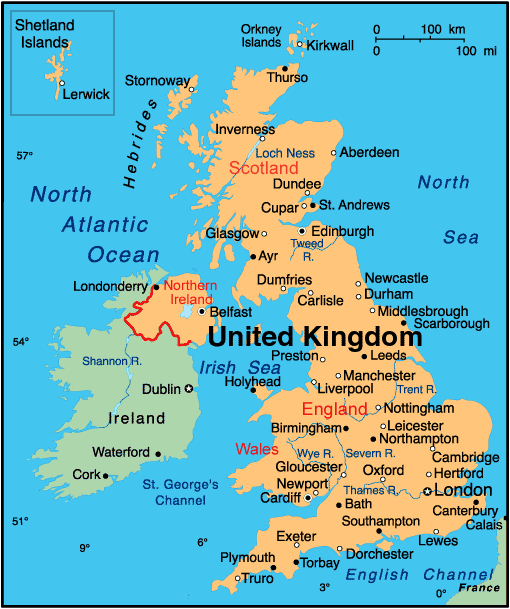
The United Kingdom of Great Britain and Northern Ireland is situated on the British Isles and lies to the north-west of continental Europe. It is separated from the continent by the English Channel and the Strait of Dover in the south and the North Sea in the east. In everyday speech the term “Great Britain” is often applied to the United Kingdom as a whole.
The British Isles consist of two main islands (Great Britain and Ireland) and a large group of smaller islands. Great Britain is separated from Ireland by the Irish Sea. Historically the territory of Great Britain is divided into 3 parts: England, Scotland and Wales. It doesn’t include Northern Ireland. The population of Great Britain is over 60 million people. The total area is 209 000 km 2 (two hundred and nine thousand square kilometers).
The British landscape is very varied. Geographically the island of Great Britain is made up of three main regions: Lowland, Midland and Highland Britain. The Midlands occupy central counties of England. This is a region of valleys and low hills. Lowland Britain covers the territory of eastern and southern England. Highland Britain comprises Scotland, most of Wales, the Pennine Chain and the Lake District in England. Scotland and Wales are the most mountainous parts of Great Britain. Ben Nevis in Scotland is the highest point (1343 metres). Along the western coast runs the mountain range of Cumberland. The Cheviot Hills mark the boundary between England and Scotland.
The rivers in Great Britain are quite short and most of them flow in the eastward direction. The rivers (the Thames, the Severn, the Tweed, the Trent, the Tyne) never freeze in winter and allow all-year navigation.
Перевод
Соединенное Королевство Великобритании и Северной Ирландии расположено на Британских островах и лежит к северо-западу от континентальной Европы. От континента его отделяют пролив Ла-Манш и Па-де-Кале на юге и Северное море на востоке. В повседневной жизни термин «Великобритания» часто применяется ко всему Соединенному Королевству в целом.
Британские острова состоят из двух основных островов (Великобритании и Ирландии) и большой группы малых островов. Великобританию отделяет от Ирландии Ирландское море. Исторически территория Великобритании разделена на три части: Англию, Шотландию и Уэльс. Она не включает в себя Северную Ирландию. Население Великобритании превышает 60 миллионов человек. Общая территория составляет 209 000 кв.км.
Британский ландшафт очень разнообразен. Географически остров Великобритании сложился из трех основных местностей: низменности, средней полосы и высокогорья Британии. Средняя полоса занимает центральные графства Англии. Это местность с долинами и низкими холмами. Низменность Британии покрывает территорию восточной и южной Англии. Высокогорная Британия состоит из Шотландии, большей части Уэльса, Пеннинских гор и Озерного края в Англии. Шотландия и Уэльс являются наиболее гористыми частями Великобритании. Бен Невис в Шотландии – это самая высокая точка (1343 метра). Вдоль западного побережья пролегает горная цепь Камберленд. Горы Чевиот-Хилс отмечают границу между Англией и Шотландией.
Реки Великобритании довольно коротки, и большая их часть течет в восточном направлении. Реки (Темза, Северн, Твид, Трент, Тайн) никогда не замерзают зимой и допускают круглогодичную навигацию.
Географическое положение Великобритании (топик)
Geographical position of the United Kingdom
The United Kingdom of Great Britain and Northern Ireland is situated on the British Isles which consist of two main islands, Great Britain and Ireland, and a great number of small islands, including the Orkney Islands, the Isle of Man, the Channel Islands, the Shetland Islands, and some others. The United Kingdom is made up of four countries: England, Wales, Scotland and Northern Ireland. Their capitals are London, Cardiff, Edinburgh and Belfast respectively. Great Britain consists of England, Scotland and Wales and does not include Northern Ireland.
The United Kingdom has a total area of approximately two hundred and forty five thousand square kilometers. The capital of the country is London. It is located in southeastern England. London has a population of about seven million people, including its suburbs. Birmingham is the United Kingdom’s second-largest city. The total population of the UK is over sixty three million people. About eighty percent of the population is urban.
England and Wales occupy the southern part of Great Britain, while Scotland occupies its northern part. The British Isles are separated from the European continent by the English Channel and washed by the North Sea, the Atlantic Ocean and the Irish Sea.
The rivers in Great Britain are not very long. The most main rivers are the Thames, the Severn, the Trent, the Tees, the Tyne, the Eden and some others.
Scotland and Wales are the most mountainous parts of the UK. On the border of England and Scotland there is a range of hills which is called the Cheviot Hills. The highest mountain in Great Britain is Ben Nevis in Scotland, while the highest mountain in England is Scafell Pike in the Lake District.
The climate of Great Britain is greatly affected by the Atlantic and the warm current of Golf Stream. As a result, the weather is changeable and the climate is mild: winters are not so severe and summers are not as hot as in the rest of Europe. The overall climate in England is called temperate maritime. July is normally the warmest month in England while January and February are the coldest. As the English have such a variable climate, it is difficult to predict the weather. The average temperature is not much lower than 0 °C in winter and not much higher than 30 °C in summer, but mostly the thermometer only reaches 26 °C.
The main ports are Portsmouth, Plymouth, Dover, Cardiff and Edinburgh, the capital of Scotland.
Географическое положение Соединенного королевства Великобритании
Соединенное Королевство Великобритании и Северной Ирландии расположено на Британских островах, состоящих из двух основных островов, Великобритании и Ирландии, и множества маленьких островов, включая Оркнейские острова, остров Мэн, Шетландские и Нормандские острова и другие. Соединенное Королевство состоит из четырех стран: Англия, Уэльс, Шотландия и Северная Ирландия. Их столицами являются Лондон, Кардифф, Эдинбург и Белфаст соответственно. Великобритания состоит из Англии, Шотландии, Уэльса и не включает в себя Северную Ирландию.
Общая площадь Соединенного Королевства составляет приблизительно двести сорок пять тысяч квадратных километров (245 000 км2).
Столица страны — Лондон. Он располагается на юго-востоке Англии. Численность населения Лондона составляет около семи миллионов человек, включая пригороды. Бирмингем считается вторым по величине крупнейшим городом страны. Общая численность населения Соединенного Королевства составляет более шестидесяти трех миллионов человек. Около восьмидесяти процентов населения — горожане.
Англия и Уэльс занимают южную часть Великобритании, в то время как Шотландия занимает ее северную часть. Британские острова отделены от Европейского континента проливом Ла-Манш и омываются Атлантическим океаном, Северным морем и Ирландским морем.
Реки в Англии не очень длинные. Самыми главными считаются Темза, Северн, Трент, Тис, Тайн, Идеи и некоторые другие.
Шотландия и Уэльс являются гористыми частями Великобритании. На границе Англии и Шотландии находятся горы Чевиот-Хилс. Самой высокой горой Великобритании является Бен-Невис (Шотландия), а самой высокой горой в Англии — Скофел-Пайк (Озерный край).
Климат Великобритании находится под влиянием Атлантического океана и теплого течения Гольфстрим. В результате погода в стране переменчивая, а климат умеренный: зима не такая суровая, а лето не такое жаркое, как в остальных частях Европы. В целом климат в Англии называют умеренным морским. Июль считается самым жарким летним месяцем, в то время как январь и февраль — самыми холодными зимними месяцами. Поскольку у англичан такой переменчивый климат, весьма сложно предсказать погоду даже на день. Средняя температура зимой — не ниже О °С, и не выше 30 °С летом, однако в основном температура на градуснике едва поднимается до 26 °С.
Основными портами считаются Портсмут, Плимут, Дувр, Кардифф и Эдинбург, столица Шотландии.
The Geographical Position of Great Britain
There are two large islands and several smaller ones, which lie in the north-west coast of Europe. Collectively they are known as the British Isles. The largest island is called Great Britain. The smaller one is called Ireland. Great Britain is separated from the continent by the English Channel. The country is washed by the waters of the Atlantic Ocean. Great Britain is separated from Belgium and Holland by the North Sea, and from Ireland — by the Irish Sea.
In the British Isles there are two states. One of them governs of the most of the island of Ireland. This state is usually called the Republic of Ireland. The other state has authority over the rest of the territory.
The official name of this country is the United Kingdom of Great Britain and Northern Ireland. But it is usually known by a shorter name — «The United Kingdom». The total area of Great Britain is 244,000 square km.
They say that the British love of compromise is the result of the country’s physical geography. may or may not be true, but it certainly true that the land and climate in Great Britain have a notable lack of extremes. The mountains in the country are not very high. It doesn’t usually get very cold in the winter or very not in the summer. It has no active volcanoes, and an earth tremos which does no more than rattle teacups in a few houses which is reported in the national news media. The insular geographical position of Great Britain promoted the development of shipbuilding, different training contacts with other countries.
Географическое положение Великобритании (перевод)
На северо-западном побережье Европы расположены два больших и несколько маленьких островов. Вместе они известны как Британские острова. Самый большой остров называется Великобритания. Меньший — Ирландия. Великобритания отделена от континента проливом Ла-Манш. Страна омывается водами Атлантического океана. Великобритания отделена от Бельгии и Голландии Северным морем, а от Ирландии — Ирландским морем.
На Британских островах два государства. Одно из них занимает остров Ирландию. Это государство обычно называется Ирландская Республика. Другому государству подчинена остальная территория.
Говорят, что любовь британцев к компромиссам — результат географического положения страны. Это может быть, а может и не быть правдой, но правда в том, что рельеф и климат Великобритании отличаются отсутствием каких-либо контрастов. Горы в стране не очень высокие. Зимой здесь не очень холодно, а летом не очень жарко. В стране нет действующих вулканов. Землетрясения, о которых сообщается в средствах массовой информации, вызывают разве что дребезжание чашек в нескольких домах. Островное географическое положение Великобрита-нии способствует развитию кораблестроения, разнообраз-ным торговым связям с другими странами.
 (No Ratings Yet)
  Loading.
Похожие записи
Создайте бесплатно анкету репетитора и Вас гарантировано найдут ученики.
Geographical Position of Great Britain. Географическое положение Великобритании
Geographical Position of Great Britain
The United Kingdom of Great Britain and Northern Ireland occupies the territory of the British Isles. They lie to the north-west of Europe.
Once upon a time the British Isles were an integral part of the mainland. As a result of sinking of the land surface they became segregated.
Great Britain is separated from the continent by the English Channel. The country is washed by the waters of the Atlantic Ocean.
Great Britain is separated from Belgium and Holland by the North Sea, and from Ireland — by the Irish Sea.
There are several islands along the coasts. The total area of the British Isles is 325 000 km2. The main islands are Great Britain and Ireland.
The surface of the country is much varied. Great Britain is the country of valleys and plains.
The mountains in Britain are not very high. Scotland is the most mountainous region with the highest peak, Ben Nevis.
The insular geographical position of Great Britain promoted the development of shipbuilding, different trading contacts with other countries. It has also allowed the country to stay independent for quite a long period of time.
Географическое положение Великобритании
Соединенное Королевство Великобритании и Северной Ирландии занимает территорию Британских островов. Они лежат на северо-западе Европы.
Очень давно Британские острова были частью материка. В результате затопления поверхности земли они отделились.
Великобритания отделена от материка проливом Ла-Манш. Страна омывается водами Атлантического океана.
Вдоль побережья есть ещё несколько островов. Общая площадь Британских островов- 325 000 км2. Основными островами являются Великобритания и Ирландия.
Поверхность страны достаточно разнообразна. Великобритания является страной долин и равнин.
Горы в Великобритании не являются очень высокими. Шотландия является самым горным регионом с самой высокой вершиной- Беном Невисом.
Островное географическое положение Великобритании способствовало развитию судостроения, различных торговых контактов с другими странами. Оно также позволило стране оставаться независимой довольно длительный период времени.
Географическое положение Великобритании (топик на английском)
The Geographical Position of Great Britain (2)
The United Kingdom of Great Britain and Northern Ireland is situated on the British Isles. The British Isles are separated from Europe by the English Channel. The British Isles are washed by the North Sea in the East and the Atlantic Ocean in the West.
The territory of Great Britain is divided into four parts: England, Scotland, Wales and Northern Ireland.
England is the richest, the most populated part in the country. There are mountains in the north and in the west of England, but all the rest of the territory is a plain.
Scotland is a land of mountains. Its highest peak is Ben Nevis.
The British Isles have many rivers. The longest of them is the Severn. It flows into the Irish Sea. The Thames is over 200 miles long. London, the capital of Great Britain, stands on it.
Geographical position of Great Britain is rather good as the country lies on the crossways of the sea routes from Europe to other parts of the world.
Географическое положение Великобритании (2)
Объединенное Королевство Великобритании и Северной Ирландии расположено на Британских островах., Британские острова отделены от Европы проливом Ла-Манш. Британские острова омываются Северным морем на Востоке и Атлантическим океаном на Западе.
Территория Великобритании разделена на четыре части: Англию, Шотландию, Уэльс и Северную Ирландию.
Англия — самая богатая, самая густонаселенная часть страны. Горы есть на севере и западе Англии, остальная часть территории страны — равнина.
Шотландия — земля гор. Самая ее высокая вершина — Бен Невис.
На Британских островах много рек. Самая длинная из них — Северн. Она впадает в Ирландское море. Темза длиной свыше 200 миль. Лондон, столица Великобритании, стоит на ней.
Географическая положение Великобритании довольно удачно, так как страна лежит на пересечении морских путей из Европы в другие части света.